Table of Contents
Dipsea Race :
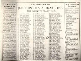
- Print, Photographic
- 1993-153-01
- Women's Dipsea Race poster
- This is a black and white photographic print of a Women's (Girls) Dipsea Race entry poster. "Bulletin Dipsea Trail Hike", Mill Valley to Willow Camp. 1/2 of a page.... View Full Record
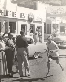
- Print, Photographic
- 1993-154-01
- Dipsea Race
- In this black and white photograph, Douglas Smith is running down Highway 1 past the Pelicans Nest in downtown Stinson Beach. Onlookers are standing by.... View Full Record
- Print, Photographic
- 1993-155-1
- Dipsea Race Participants
- This black and white photograph is of ten men (three of them in jackets and ties, the rest in casual clothing) posing on the steps of a wooden staircase running up the outside of a building. They are Dipsea race participants. The top left person is... View Full Record
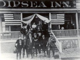
- Print, Photographic
- 1993-158-01
- Olympic club Members on the steps of the Dipsea Inn
- Black and white photograph. Planning Dipsea Race, 15 members of the Olympic Club, S.F. on the steps of the Dipsea Inn. 3 other people on the porch, one of them being possibly a woman. "Dipsea Inn"sign above the porch, 2 American flags with 42 stars d... View Full Record

- Print, Photographic
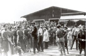
- 1993-185-01
- Dipsea Race
- In this black and white photograph we see a crowd of people gathered in a clearing at the foot of a large white building with the words HOTEL AIREY on the roof. Three cars are parked among the people and the top of a motorcycle is visible in the fore... View Full Record
- Print, Photographic
- 1993-186-01
- Dipsea race finish-Bungalow
- In this black and white photo we see a crowd of people in front of a dark building with an awning. In the left foreground there is a man with a dog on the leash. The event is the end of the Dipsea Race. The building is the Bungalow (which became the... View Full Record

- Print, Photographic
- 1993-315-01
- Dipsea Race Finish
- A photograph of unidentified people standing with their backs to the cameraman at the finish of the Dipsea race in front of the Airey Hotel. In the upper right hand corner going from left to right are Algar(De Camp) house and the Upton house.... View Full Record

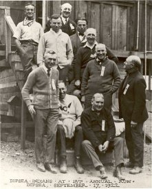
- Print, Photographic
- 1993-376
- Dipsea Indians
- The photo shows a crowd of people gathered under a sign reading 'Dipsea Indians'. Probably at the end of the Dipsea Race.... View Full Record

- Print, Photographic
- 1993-415
- Dipsea Race Participants and Friends
- A group photograph of men and women sitting in front of Airey's store. Three of the women are wearing racing numbers. Dipsea women runners with their beaus.... View Full Record
- Print, Photographic
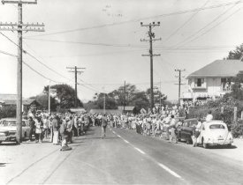
- 1993-421
- Dipsea Race Finish
- A photograph of Highway 1 in downtown Stinson Beach lined on both sides with Dipsea Race onlookers. There is a runner on the highway running toward the finish line at the corner. Airey's store is on the right and the Chevron station is on the left.... View Full Record

- Print, Photographic
- 1993-602-01
- Dipsea Girls' Finish
- This black and white photograph shows a crowd of people around a cleared area. There is an old model car parked in the left foreground with a spare tire on the back. In the midst of the crowd is a banner facing the finish area with its back towards... View Full Record
- Print, Photographic
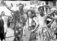
- 1999-307B-01
- Dipsea Race
- This black and white photograph is of two men and a woman posing costume. The man on the left is wearing grass or fur piece draped around his body and over o0ne shoulder. The woman in the middle is wearing a grass skirt and has paper leis around he... View Full Record
- Print, Photographic
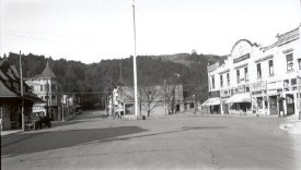
- 1999-402-01
- Lytton Square
- Downtown Mill Valley was the start of the Dipsea Race and the center of downtown is known as Lytton Square. It is an open paved street flanked by picturesque businesses. Businesses on the right side include a grocery (with awning) and realty compan... View Full Record
- Print, Photographic
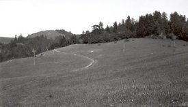
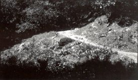
- 1999-404-01
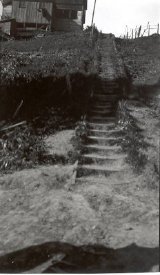
- First Flight of Stairs
- The first flight of wood-separated dirt stairs rises in an allee of trees.... View Full Record
- Print, Photographic
- 1999-405-01
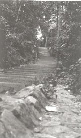
- Second Flight of Stairs
- The second flight of stairs bends up through more foliage. Large rocks border the stairs at the lower level.... View Full Record
- Print, Photographic
- 1999-406-01
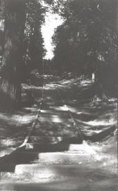
- Third Flight of Stairs
- Wooden stairs (142 total) ascend hillside that has grassy and leafy foliage on either side. At the top on the left is a wooden structure. Along the top on the right there is wood and wire fencing.... View Full Record
- Print, Photographic
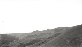
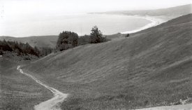
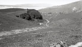
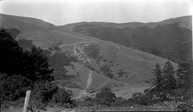
- 1999-408-01
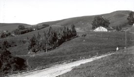
- Flying Y Ranch
- The road to the summit on the lower part of the photo passes the Flying Y Ranch. In the distance the large white barn is nestled in front of a large sheltering tree at the base of the hillside On the left there are more trees sloping down through a... View Full Record
- Print, Photographic
- 1999-409-01
- Windy Gap descent to Hauke Hollow
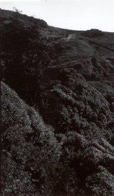
- A rather dark photo of mountain scrub with clefts in the hillside creating a "windy gap." It lies west of the summit. This spot comes after climbing 671 steps from Mill Valley before the Dipsea racers drop down to Muir Wood.... View Full Record
- Print, Photographic
- 1999-410-01
- Windy Gap, Frank's Valley
- Rolling, sloping hills with copses of trees scattered in the clefts the hills as they slope downward. The view is of Windy Gap from the road below looking up. The base of the hills are known as Frank's Valley.... View Full Record
- Print, Photographic
- 1999-411-01
- Across from Butler's, Joe's Place below
- A dense area of trees separates the hillside. In the lower corner there is a house at the edge of the treeline (Joe's place). On the far side of the trees are rolling hills and a trail line, which is Hog's Back going up and over the hills.... View Full Record

- Print, Photographic
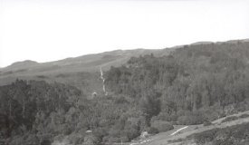
- 1999-412-01
- House at Muir Woods Creek
- A large shingled structure with a slant roof sits slightly back from the road on a sloped hillside. There is a dense growth of trees beyond it and below on the left the creek meanders into the trees. The house is surrounded by a wooden fence on the... View Full Record

- Print, Photographic
- 1999-413-01
- Hog's Back toward West
- The trail passes through open hillside along which a few telephone poles. The view is from halfway up Butler's looking back toward the west. The field is fairly flat and grassy. Trees extend along part of the skyline. More hills in the distance.... View Full Record
- Print, Photographic
- 1999-414-01
- Halfway up Butler's-Hog's Back Trail
- Hog's Back Trail skews over Butler's open land in a backward semicircle and it disappears over the hill. Pine trees edge the crest. Telephone poles stretch across the middle of the landscape.... View Full Record
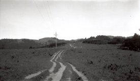
- Print, Photographic
- 1999-415-01
- Open Trail Along Bulter's- Hogs Back
- Looking at the trail which consists of 3 or 4 ruts in the ground as it extends into the distance. There is one nearby telephone pole alongside the trail and a string of more in the distance. The landscape is rather bare except for some clumps of th... View Full Record
- Print, Photographic
- 1999-417-01
- View of Trail after entering Woods
- This is a view off trail after entering the woods. The branches of the trees make a U-shape beyond which is the slope of the mountain and one presumes the ocean or layer of fog,... View Full Record
- Print, Photographic
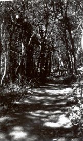
- 1999-418-01
- Deer Park from Shade
- A dirt path is seen dappled by sunlight running through the branches of trees that arch over it. Trees line the path as far as the eye can see.... View Full Record
- Print, Photographic
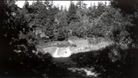
- 1999-419-01
- Woods after Deer Park
- Coming out of the shade of the woods, the trail passes through a small sloping open field before it reenters the dense grove of trees on the far side. The trail looks more like a rutted track than a footpath.... View Full Record

- Print, Photographic
- 1999-420-01
- Up grade in woods to Summit
- Trail runs besides a sloping hillside with trees growing on either side, their branches extending over the trail. Sunlight casts shadows on the trail and hillside through the dense overgrowth.... View Full Record

- Print, Photographic
- 1999-421-01
- Trail ahead to highest point on Dipsea Trail
- The trail leaves the woods (tree branches cast shadows on the trail) and extends in the distance uphill before descending at the horizon.... View Full Record
- Print, Photographic
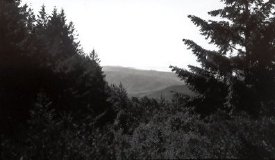
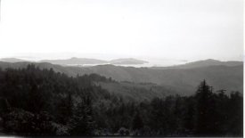
- 1999-422-01
- Looking South on Dipsea Trail from Summit
- Panoramic view from the summit looking south over treetops, hills, and ocean in the distance with land masses arising out of the water.... View Full Record

- Print, Photographic
- 1999-423-01
- First View of Lone Tree
- Dipsea Trail etches a path along and over rolling hills before descending over the edge. There is a more distant tree higher on the hill to the right. Wooden fencing stretches along the hill, but separate from the trail, until it disappears over th... View Full Record

- Print, Photographic
- 1999-424-01
- Lone Tree Closeup
- Lone (Redwood) Tree stands at the right edge of the photo in a scrubby, rocky landscape. The trail is off to the left. On the distant hillside a couple of telephone poles rise up into the horizon and pickets line the cliff edge.... View Full Record
- Print, Photographic
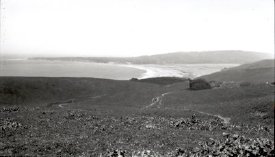
- 1999-425-01
- Trail from Lone Tree-Swoop Hollow
- Trail from Lone Tree crosses the land at the base of a sloping hillside, also known as Swoop Hollow. Trees grow out of the crevice of the adjoining hills. First view of breakers in the distance and Bolinas Bay.... View Full Record

- Print, Photographic
- 1999-426-01
- Trail with Ocean View
- Dipsea Trail runs along left edge of photo along an open field with wild grasses. A row of trees runs along the horizon ahead, partially obscuring the view of Bolinas Bay. The western tip of Bolinas is visible.... View Full Record

- Print, Photographic
- 1999-427-01
- Devil's Slide-Ocean in distance
- Trail is marked by ruts in the hillside as it extends overland and across the broad terrain. Area is known as Devil's Slide as the trail in the foreground descends steeply before is rises again on the opposite hillside. There are patchs of trees ex... View Full Record

- Print, Photographic
- 1999-428-01
- View from Hog's Back
- Looking down Hog's Back (although no longer called this). This part of the trail is now known as Devil's Slide. It etches its way over some land which has areas of rock and slopes down on the left and up on the right, where a single tree grows. A... View Full Record
- Print, Photographic
- 1999-429-01
- Steep Ravine Trail Crossing
- Steep Ravine Trail crossing curves narrowly around a brambled, rocky hillside before it enters wooded area ahead.... View Full Record

- Print, Photographic
- 1999-430-01
- Looking back on Hog's Back
- A double dirt track trail runs along the base of and towards a hillside. Slightly higher on the left, separated by weedy growth, is another wider path that has an open swing-type gate across it and wire fencing extending uphill from it. Trees and b... View Full Record
- Print, Photographic
- 1999-431-01
- Trail ahead from Near Ranch
- From the top of the hill, looking north over Bolinas Bay and Lagoon to the peninsula, the trail appears etched into the land below as it disappears between the cleft in the hills. What appears to be a giant boulder rests midway on a hilltop. In the... View Full Record
- Print, Photographic
- 1999-432-01
- Trail Down to Road
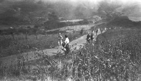
- The trail meanders downhill, past an enormous copse of trees (or large rock), to the road (not visible). Some runners dot the trail. Beyond the cleft in the hills forming the horizon one can see Bolinas Bay and peninsula.... View Full Record

- Print, Photographic
- 1999-433-01
- Further Down Trail
- Further down the trail, the dirt track jogs around clumps of shrubbery. A wood and wire fence (with a wooden gate at the top) runs the length of the land as it slopes toward the ocean. Beyond the fencing are various houses scattered about the hills... View Full Record

- Print, Photographic
- 1999-434-01
- Road Down to Bridge
- The road leading down to the bridge (from Big Rock near gate) is wide and looks well-maintained. It passes several houses on the left and many more are spread across the hillside up ahead. A dirt path that is delineated by wood and wire fencing run... View Full Record
- Print, Photographic
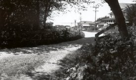
- 1999-435-01
- Main Street of Camp
- Looking across the bridge from under the trees, the main street curves to the left, past several structures, the first being the largest - a 2-story Sea Beach Hotel with extended porch and ending with the Hotel Airey. The street is also lines with t... View Full Record
- Print, Photographic
- 1999-436
- Dipsea Hike Finish
- An original photograph of people gathered near the finish. The photo was taken from the porch of Hotel Airey as the Red Crown Gasoline sign indicates and it is aiming toward the Bungalow grocery store. On the right middle of the photograph a canvas s... View Full Record

- Print, Photographic
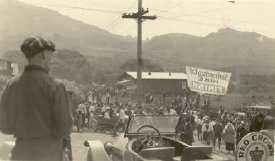
- 1999-437-01
- Hotel Airey and Dipsea Indian Flag
- A black and white photograph of people gathering near the finish of the Dipsea Race. In the center a banner reading "Dipsea Indians" hangs from a rope stretched from the electrical pole in front of the Hotel Airey. The Hotel Airey is in the upper rig... View Full Record

- Print, Photographic
- 1999-438-01
- People Waiting for the Runners
- A black and white photograph of the Sausalito-Bolinas Road (Shoreline Highway 1) on the Dipsea Race day. "Dipsea Day in Stinson Beach", "Waiting for the Dipsea Trail Runners", "Olympic Club Race" are written on the surface of the photo in white hand... View Full Record
- Print, Photographic
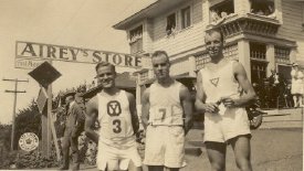
- 1999-439-01
- 3 runners
- A black and white photograph of 3 runners standing in front of the sign, Airey's Store. The runners are all men and wear white sleeveless t-shirts and white shorts. The man on the left's shirt has a logo "Y" in a octagon and he has a runner number 3... View Full Record
- Print, Photographic
- 1999-440-01
- Joe's Pine and Hog's Back on Dipsea Trail
- A black and white photograph of the trail with a couple of runners. There are 2 big hills and pine trees in foreground. The hill in the front has a trail coming down ending at 2 houses facing a road. The front side of the road has pine trees. Handwr... View Full Record
- Print, Photographic
- 1999-441-01
- Runners on the Trail
- A black and white photograph of runners coming down the hill near Stinson Breach. The fog is rising on the distant hills. The trail runs along the ranch fence of possibly the White Gate Ranch, also the division of Rancho Bolinas and Rancho Sausalito... View Full Record

- Poster
- 2007A-113-01
- Dipsea Breakfast
- A poster announcing the Dipsea Breakfast for June 14, 1981. The breakfasts were served by Stinson Beach Community Center inc. for its Fundraising aiming at the people who come over for the Dipsea Race. All you can eat pancake breakfasts were served f... View Full Record

- Poster
- 2007A-114-01
- Dipsea Breakfast Eater
- A poster announcing the Dipsea Breakfast for June 12, 1983. The breakfasts were served by Stinson Beach Community Center inc. for its Fundraising aiming at the people who come over for the Dipsea Race. All you can eat pancake breakfasts were served f... View Full Record

- Booklet
- 2015L-103-01
- Dipsea Race
- Official program of 100th anniversary of the Dipsea Race. The program appears to be published every year but this is a special edition commemorating 1905 to 2005 of the race. This 34 pages booklet has the race course trail map, the history, list of a... View Full Record